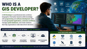
top of page

Latest GIS & Remote Sensing Blogs
Search


NDVI Analysis and Reclassification in ArcGIS Pro: Landsat & Sentinel Workflows
Introduction Normalized Difference Vegetation Index (NDVI) is used to quantify vegetation greenness and is useful in understanding vegetation density and assessing changes in plant health. It is a numerical indicator which uses the visible and near-infrared bands of the electromagnetic spectrum. Purpose Of NDVI Analysis 1) To estimate agricultural parameters such as crop yields, pasture performance, and rangeland carrying capacity. 2) To enhance vegetation analysis using re
Hridya Geevaraj
Dec 8, 20252 min read


Automating Buffer and Slope Analysis in ArcGIS Pro with Model Builder
Introduction Geospatial analysis often involves repetitive workflows—buffering multiple administrative units, processing several raster files, or applying the same transformation repeatedly. ArcGIS Pro’s Model Builder offers an efficient solution by automating these processes with a drag-and-drop visual programming environment. In this blog, we walk through two automation workflows in ArcGIS Pro: 1. Creating buffer zones for eight administrative blocks 2. Performing slope ana
Arjun M S
Dec 4, 20252 min read


Integrating BIM, IoT, and GIS for Smarter Infrastructure Maintenance
Introduction Infrastructure maintenance is no longer just about reacting to failures — it is about predicting them before they happen. As cities and organizations embrace digital transformation, the convergence of Building Information Modeling (BIM), Internet of Things (IoT), and Geographic Information Systems (GIS) is redefining how we monitor, manage, and maintain critical assets. This blog explores how integrating these three technologies creates a powerful, real-time main
Prasanna P N
Aug 6, 20252 min read


BIM-GIS Integration for Smarter Infrastructure: Simulating Urban Flooding with 3D Spatial Intelligence
Introduction Imagine standing in the heart of a city moments before a heavy monsoon storm. Streets flood, traffic halts, and buildings stand helpless. Now imagine if we could predict exactly which road will be submerged, which entrance of a school will be underwater, and how the water will flow around critical infrastructure—before the first drop falls. That’s the promise of BIM-GIS integration—a synergy of precision and context, detail and landscape, building-level insight a
Hansa
Jul 31, 20255 min read


Using Revit Models for Utility Network Planning in GIS
Introduction Utility networks are the hidden lifelines of modern cities — from water pipelines to electrical grids. Yet, planning, managing, and upgrading these networks remains a challenge, especially when they span vast and varied urban geographies. This is where the fusion of Revit’s detailed BIM modeling and GIS’s spatial intelligence proves invaluable. In this blog, we explore how Revit models are being used to design utility infrastructure and how integrating them into
Prasanna P N
Jul 24, 20253 min read


How to Secure GeoServer Layers with Role-Based Access and Token Authorization
Introduction Imagine you're building a geospatial dashboard for city planners in Bengaluru. Your team publishes layers like traffic density, fiber cable layouts, and sensitive infrastructure. But without proper access control, these datasets are exposed to the public or could be edited by unauthorized users — a serious risk in urban planning. In this blog, you'll learn how to secure your GeoServer layers using Role-Based Access Control (RBAC) and Token-Based Authentication. W
SAHANA A
Jul 15, 20256 min read


Mapping Streetlights offline with Qfield & field maps: A real-world workflow for Indian urban surveys
Introduction Urban infrastructure is the invisible backbone of every city and streetlights are one of the most critical yet often neglected components. Whether it’s improving public safety or reducing energy waste, managing streetlight data requires accurate ground-level information. In this blog, we go beyond theory by testing both tools through a hands-on streetlight inventory survey conducted in my own neighborhood. Though a small-scale example, it realistically demonstra
Nithin B R
Jul 3, 20254 min read


Spatial Querying with Django REST API: Filtering, Bounding Box, and Nearest Feature
Introduction Imagine building an application that shows the nearest hospitals to a user, filters restaurants within a city, or displays...
Manikanta S
Jun 30, 20252 min read


Unlocking Land Potential with Suitability Analysis Using MCDA in QGIS: A Case Study of Bengaluru
Introduction Suitability analysis is a vital component of spatial planning, allowing decision-makers to identify the most appropriate locations for specific land uses based on multiple criteria. In a world facing rapid urbanization, food insecurity, and climate change, the demand for smart land use decisions has never been greater. Whether it's identifying the best site for agriculture, infrastructure, or conservation, making the right choice means balancing environmental, so
IMPANA S V
Jun 26, 20254 min read


Smart Labeling in QGIS: A Practical Guide to Clean and Clear Map Design
Introduction In GIS, a well-designed map doesn’t just show features—it communicates information clearly and effectively. Labels play a major role in this. Whether it’s place names, population data, land parcel IDs, or facility types, labels help users interpret the data at a glance. But as your map grows more detailed, with hundreds or thousands of features, default labels can quickly become overwhelming. That’s where smart labeling in QGIS comes in. This blog explores practi
Hansa
Jun 24, 20254 min read


From CAD to GIS: A Practical Guide to Using AutoCAD Data in ArcGIS Pro
Introduction The convergence of CAD (Computer-Aided Design) and GIS (Geographic Information Systems) has unlocked new possibilities for professionals working in urban planning, civil engineering, environmental management, and infrastructure development. AutoCAD is a widely used tool for designing and drafting, while ArcGIS Pro provides powerful spatial analysis and mapping capabilities. Integrating CAD data into GIS platforms like ArcGIS Pro allows for enhanced geospatial ins
Ajay K
Jun 18, 20252 min read


Field Data Collection Made Easy with QField and ArcGIS Field Maps: A Step-by-Step Comparison
Introduction: Field data collection is at the heart of effective GIS workflows — whether it's mapping property boundaries, documenting infrastructure, or conducting environmental surveys. Traditionally, this process involved manual forms, handwritten notes, and redundant data entry. Today, tools like ArcGIS Field Maps and QField allow you to collect structured data digitally, directly on-site, and link it to spatial features on a map. This blog walks you through two practical
Nithin B R
Jun 17, 20253 min read
bottom of page
.png)