.png)
Smart Farming: Technologies, Benefits, Applications, and Future of Agriculture
- Satyaranjan Swain
- 16 minutes ago
- 4 min read

Agriculture is undergoing a significant transformation. Farmers today face challenges such as climate variability, water scarcity, rising input costs, labor shortages, pest outbreaks, and the growing need for sustainable food production.
To address these challenges, the agriculture sector is increasingly adopting smart farming technologies. Smart farming combines digital tools, data analytics, automation, artificial intelligence, and geospatial technologies to improve decision-making and farm productivity.
From satellite monitoring and precision irrigation to AI-powered crop analysis and farm management platforms, smart farming is helping agricultural stakeholders make informed decisions based on real-time data.
What is Smart Farming?
Smart farming refers to the use of advanced technologies to monitor, manage, and optimize agricultural operations.
It integrates various technologies such as:
Geographic Information Systems (GIS)
Remote Sensing
Satellite Imagery
Artificial Intelligence (AI)
Internet of Things (IoT)
GPS Technology
Drones and UAVs
Data Analytics
Cloud Computing
These technologies work together to provide actionable insights that help improve crop productivity, resource utilization, and overall farm performance.
Why Smart Farming is Important
Traditional farming often relies on manual observation and experience-based decision-making. While valuable, these approaches may not always provide accurate and timely information.
Smart farming enables:
Real-time farm monitoring
Early detection of crop stress
Improved irrigation management
Better resource allocation
Reduced operational costs
Increased crop productivity
Sustainable farming practices
As global food demand continues to rise, smart agriculture plays a critical role in improving agricultural efficiency and resilience.
Key Technologies Used in Smart Farming
Geographic Information Systems (GIS)
GIS helps farmers visualize and analyze spatial data related to fields, crops, soil conditions, water resources, and infrastructure.
Applications include:
Field mapping
Land suitability analysis
Precision agriculture
Crop zoning
Resource planning
GIS provides location-based intelligence that supports better agricultural decision-making.
Remote Sensing and Satellite Monitoring
Satellite imagery enables continuous monitoring of agricultural land without physical field visits.
Farmers and agribusinesses can analyze:
Crop health
Vegetation conditions
Soil moisture
Water stress
Land-use patterns
Seasonal changes
Popular vegetation indices include:
NDVI (Normalized Difference Vegetation Index) - Measures vegetation health, vigor, and greenness.
NDMI (Normalized Difference Moisture Index) - Measures vegetation and soil moisture content, useful for irrigation monitoring and water stress detection.
EVI (Enhanced Vegetation Index) - Provides improved vegetation monitoring in dense crop canopies and reduces atmospheric effects.
SAVI (Soil Adjusted Vegetation Index) - Improves vegetation analysis in areas where exposed soil influences satellite measurements.
NDRE (Normalized Difference Red Edge Index) - Detects crop stress, nutrient deficiencies, and chlorophyll variations earlier than NDVI.
GNDVI (Green Normalized Difference Vegetation Index) - Measures chlorophyll concentration and photosynthetic activity, often used for nutrient management and yield assessment.

These indicators help identify potential problems before they become visible to the human eye.
AI in Agriculture
AI is increasingly used to process large volumes of agricultural data and generate predictive insights.
Applications include:
Yield prediction
Disease detection
Pest monitoring
Crop recommendation
Risk assessment
Farm forecasting
AI enables proactive farm management rather than reactive problem-solving.

Internet of Things (IoT)
IoT devices collect real-time data from the field through connected sensors.
Common IoT applications include:
Soil moisture monitoring
Weather monitoring
Water management
Temperature tracking
Humidity monitoring
IoT provides continuous field-level intelligence for informed decision-making.
Drones and UAV Technology
Drones have become valuable tools for precision agriculture.
Applications include:
Crop scouting
Field surveys
Plant health assessment
Pest detection
Precision spraying
Drone-generated imagery provides highly detailed insights at the field level.
Benefits of Smart Farming
Increased Crop Productivity
Continuous monitoring allows farmers to identify issues early and take corrective actions before crop performance is affected.
Reduced Input Costs
Smart farming helps optimize the use of:
Fertilizers
Pesticides
Water
Labor
This reduces unnecessary expenses and improves profitability.
Better Water Management
Water scarcity is becoming a major challenge worldwide.

Smart irrigation systems use real-time moisture and weather data to improve irrigation efficiency and reduce water wastage.
Early Risk Detection
Farmers can detect:
Crop stress
Disease outbreaks
Pest infestations
Drought conditions
Nutrient deficiencies

Early detection reduces crop losses and improves farm resilience.
Sustainable Agriculture
Smart farming supports sustainable agricultural practices by improving resource efficiency and reducing environmental impact.
Applications of Smart Farming
Smart farming is widely used across:
Crop Farming
Cereals
Vegetables
Pulses
Oilseeds
Plantation Agriculture
Coconut
Coffee
Tea
Rubber
Cocoa
Horticulture
Fruits
Orchards
Greenhouses
Agribusiness Operations
Large-scale farming
Supply chain monitoring
Contract farming
Farm advisory services

Government Agriculture Programs
Governments increasingly use geospatial technologies and smart agriculture platforms for:
Crop assessment
Yield estimation
Resource management
Agricultural planning
Future of Smart Farming
The future of agriculture will be increasingly driven by data, automation, and intelligence.
Emerging trends include:
AI-powered farm management
Digital Twin technology
Predictive agriculture
Autonomous farming equipment
Real-time satellite monitoring
Climate-smart agriculture
These innovations will help farmers improve productivity while ensuring long-term sustainability.
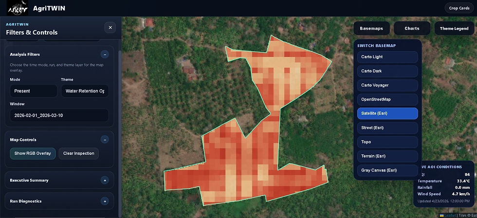
How Digital Twin Technology is Transforming Agriculture
One of the most promising developments in smart farming is the use of Digital Twin technology.
A Digital Twin creates a virtual representation of a farm by combining:
Satellite Intelligence
GIS Analytics
Artificial Intelligence
IoT Monitoring
Field Observations
This enables agricultural stakeholders to monitor, predict, and optimize farm performance from a single platform.
Modern digital agriculture solutions provide real-time visibility into crop conditions, water management, risk detection, yield forecasting, and field operations, helping users make faster and more informed decisions.
Conclusion
Smart farming is reshaping modern agriculture by combining technology, data, and intelligence to improve decision-making and productivity.
Through GIS, remote sensing, satellite monitoring, AI, IoT, and predictive analytics, farmers and agricultural organizations can gain deeper insights into their operations and respond proactively to changing field conditions.
As agriculture continues to evolve, smart farming technologies will play a crucial role in achieving higher productivity, resource efficiency, and sustainable food production.


Comments