
LiDAR Data Processing and Terrain–Object Extraction in ArcGIS Pro

Abstract
This technical workflow demonstrates the processing of airborne LiDAR point-cloud data in ArcGIS Pro to produce a structured dataset for terrain and above-ground feature analysis. The workflow begins with LAZ-to-LAS preparation and LAS Dataset creation, followed by LiDAR point classification into ground (Class 2), buildings (Class 6), and vegetation-related height information. Surface products are then derived as a Digital Surface Model (DSM) and a Digital Terrain Model (DTM). The study emphasizes the importance of LAS filtering because the selected point classes directly control what is represented in each raster product. The resulting datasets provide a foundation for 3D visualization, building height assessment, vegetation analysis, terrain modelling, urban mapping, drainage studies, and subsequent geospatial analysis.
Introduction
Light Detection and Ranging (LiDAR) is an active remote-sensing technology that measures distance by emitting laser pulses and recording their returns from the Earth's surface and objects above it. Unlike a conventional aerial photograph, a LiDAR point cloud contains threedimensional elevation information and can therefore be analysed to distinguish terrain from buildings, vegetation, and other elevated features.
In this workflow, the objective is not simply to visualize a point cloud, but to convert the raw LiDAR information into meaningful geospatial layers. The processing sequence is deliberately ordered so that each stage supports the next: the LAS Dataset organizes the point cloud; ground classification identifies terrain returns; building classification isolates structures; height analysis describes above-ground features; and DSM and DTM products represent surface elevation and bare-earth terrain respectively.
ArcGIS Pro is used as the principal processing environment. The workflow is suitable as a practical technical demonstration for urban mapping, 3D city modelling, vegetation assessment, terrain analysis and other LiDAR-supported GIS applications.
Aim and Objectives
• Prepare compressed and uncompressed LiDAR point-cloud data for GIS processing.
• Create and configure an ArcGIS Pro LAS Dataset for efficient 3D visualization and filtering.
• Classify LiDAR points into ground and building categories and inspect the classification results.
• Use elevation/height information to examine above-ground features, including vegetation structure.
• Generate a Digital Surface Model (DSM) from the selected LiDAR returns.
• Generate a Digital Terrain Model (DTM) using the ground class.
• Document the correct LAS Filter settings and explain how the selected points affect each output.
• Produce a reproducible workflow suitable for further 3D GIS and remote-sensing analysis.

Methodology
The complete processing chain is shown below. Each stage produces an intermediate dataset or decision that controls the following stage.

LAS Dataset Creation
What it is: The LAS Dataset is the working container used by ArcGIS Pro to reference the LiDAR LAS files, inspect their metadata and display the point cloud without converting every point into a conventional feature class. It provides the interface for classification filtering, return filtering, elevation visualization and subsequent raster generation.
ArcGIS Pro tools / procedure: Create LAS Dataset (Data Management Tools) → add the LAS files → confirm spatial reference and extent → add the LAS Dataset to a 3D Scene → inspect point density, elevation and returns.
Expected output: A functioning .lasd dataset that can be filtered and visualized in ArcGIS Pro.
LAS Filter note: LAS Dataset.

Ground Classification
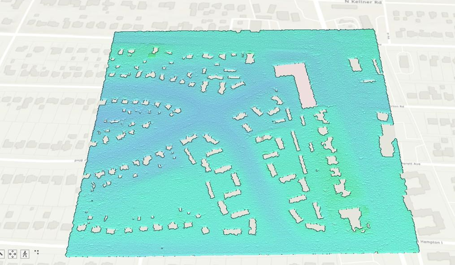
What it is: Ground classification identifies points representing the terrain surface. This is fundamental because a bare-earth terrain model must not be dominated by trees, buildings or other objects. Ground points provide the elevation basis for the DTM.
ArcGIS Pro tools / procedure: Classify LAS Ground (3D Analyst Tools). Review the classification in the LAS Dataset. In LAS Filter, select Classification Codes → 2 Ground when the objective is to display or process only terrain points.
Expected output: A ground-only point cloud representing the terrain beneath above-ground objects.
LAS Filter note: Class 2 — Ground.
Building Classification
What it is: Building classification isolates LiDAR returns associated with structures. This is useful for urban feature extraction, 3D building interpretation, building height assessment and city modelling. It is distinct from ground classification because building points represent the roof/surface of structures rather than the terrain beneath them.
ArcGIS Pro tools / procedure: Classify LAS Building (3D Analyst Tools), inspect the resulting Class 6 points, and use the LAS Filter to isolate Classification Codes → 6 Building when checking the result.
Expected output: A building-focused LiDAR layer containing Class 6 points, as shown in the project visualization. LAS Filter note: Class 6 — Building.

Height / Above-Ground Feature Analysis
What it is: Height analysis measures how far an object rises above the terrain. This is especially useful for vegetation because tree crowns occur above the ground and their height can be used to distinguish low, medium and high vegetation or to support canopy structure analysis. The same concept can also support building height assessment when roof elevation is compared with terrain elevation.
ArcGIS Pro tools / procedure: Use Classify LAS By Height where appropriate for height-based point classification. For quantitative height, use the difference between surface elevation and terrain elevation (conceptually: object height = DSM − DTM). Inspect the height pattern in 3D and verify vegetation and building areas.
Expected output: A height-based visualization of elevated objects. It supports vegetation structure interpretation but should not be described as a species-level vegetation classification without additional spectral or field information.
LAS Filter note: Elevation / relative height.

Digital Surface Model (DSM)
What it is: DSM means Digital Surface Model. It represents the elevation of the Earth's surface together with objects located on it, such as buildings, trees and other above-ground features. Therefore, a DSM is appropriate when the analysis needs the top of the observed surface rather than bare terrain.
ArcGIS Pro tools / procedure: Use LAS Dataset To Raster (Conversion Tools). Value Field →
Elevation. Interpolation Type → Binning (as demonstrated). Cell Assignment → Average. Void Fill Method → Linear. Output Data Type → Floating Point. Sampling Type → Cell Size. Choose an appropriate cell size for the point density and required map scale. For a DSM, do not restrict the LAS Filter to ground-only points; use All relevant classes/returns required to represent the surface.
Expected output: A continuous raster surface containing terrain plus above-ground features.
The project DSM visualization shows elevated buildings and vegetation as part of the surface.
LAS Filter note: Digital Surface Model.

Digital Terrain Model (DTM)
What it is: DTM means Digital Terrain Model. It represents the bare-earth terrain by removing above-ground objects such as buildings and vegetation from the elevation representation. A reliable DTM is therefore dependent on accurate ground classification.
ArcGIS Pro tools / procedure: First set the LAS Dataset LAS Filter to Classification Codes → 2 Ground only. Then use LAS Dataset To Raster with Value Field → Elevation and the required interpolation, cell size and void-fill settings. Do not leave all classes selected when the objective is a bare-earth DTM.
Expected output: A terrain-only raster representing the ground surface. This is the correct basis for slope, aspect, drainage, watershed and terrain-profile analysis.
LAS Filter note: Digital Terrain Model.

LAS Filter Selection — Critical Processing Rule
The LAS Filter controls which LiDAR points are passed to visualization or raster generation. The same LAS Dataset can therefore produce different products simply by changing the selected classification codes.

Results
The processed LiDAR dataset provides a sequence of increasingly meaningful geospatial products. The LAS Dataset establishes the point-cloud framework; ground classification isolates terrain; building classification isolates structures; and height visualization exposes the vertical organization of above-ground objects.
The DSM retains the elevation of the observed surface, including buildings and vegetation. In contrast, the DTM is produced from ground-classified points and therefore provides a representation of the underlying terrain. The visual difference between these products is important: the DSM preserves object height, while the DTM removes above-ground objects as far as the ground classification permits.
The height visualization is particularly useful as an intermediate analytical layer. High values can indicate tall vegetation or structures, while lower values may correspond to shorter vegetation or lower objects. However, height alone should not be treated as a complete vegetation species identification method.

Quality Control and Validation
• Check the LAS Dataset spatial reference, vertical units, extent and file paths before processing.
• Inspect point density and gaps; very large voids can create unreliable raster surfaces.
• Verify that ground points are actually on the terrain and are not systematically missing beneath vegetation.
• Inspect Class 6 building points against the 3D scene and aerial reference where available.
• Compare DSM and DTM visually. Areas with buildings and trees should show substantially higher DSM values than DTM values.
• Check raster cell size against LiDAR point density; an unnecessarily small cell size does not create information that is not present in the point cloud.
• Inspect edge effects and interpolation artefacts, especially around sparse areas and voids.
• For quantitative building or vegetation height, validate selected objects using independent measurements where possible.
Applications
• Urban 3D mapping and city modelling
• Building footprint and building-height analysis
• Vegetation height and urban tree-canopy assessment
• Terrain and elevation modelling
• Drainage, slope and watershed analysis
• Flood and surface-runoff modelling
• Visibility and line-of-sight studies
• Digital twin and 3D GIS workflows
• Infrastructure and asset mapping
Advanced Analysis and Future Improvements
The workflow can be extended beyond the current products. A normalized height surface can be created by subtracting the DTM from the DSM, producing an above-ground height model. This is a powerful basis for tree-canopy height mapping and building-height analysis.
For vegetation, height alone is not sufficient for species identification. A stronger workflow would combine LiDAR-derived canopy height and structure with multispectral or hyperspectral imagery, vegetation indices, object-based image analysis and field reference data. This can support species-group or vegetation-type mapping with appropriate validation.
For urban digital twins, the classified LiDAR point cloud can be combined with building footprints, road networks, imagery, terrain and other GIS layers. Building height and roof elevation can then support 3D feature generation and contextual visualization.
Future improvements should include accuracy assessment, point-density reporting, vertical accuracy checks, automated classification refinement, canopy height modelling, building footprint extraction, and integration with WebGIS or 3D scene services.
Limitations
• Classification accuracy depends on LiDAR point density, scan geometry, terrain complexity and the quality of the classification algorithm.
• Buildings and vegetation can be difficult to separate where roofs are partially obscured or tree crowns overlap structures.
• A height-based visualization indicates vertical structure but does not by itself identify vegetation species.
• DSM and DTM quality depends on appropriate point filtering, interpolation and cell-size selection.
• Raster products may contain interpolation artefacts where point density is low or where gaps exist in the source point cloud.
Conclusion
This ArcGIS Pro workflow converts LiDAR point-cloud data into a structured set of terrain and above-ground information. The key principle is that classification and filtering determine the meaning of the final surface. Ground points (Class 2) provide the foundation for a DTM, while a DSM requires the surface returns needed to represent buildings, vegetation and terrain. Building classification (Class 6) enables focused urban analysis, and height analysis provides an important intermediate layer for vegetation and structural assessment.
The workflow therefore provides a practical foundation for professional LiDAR processing, 3D GIS, urban analysis, vegetation assessment and digital-twin applications. The next stage should focus on validation and on deriving advanced products such as normalized height models, treecanopy metrics, building heights and integrated 3D GIS layers.
Building on this processing workflow, LiDAR for precision farming supports crop, canopy and terrain mapping.


Comments