.png)

Our Geospatial Solutions
Explore our comprehensive range of geospatial solutions designed to tackle real-world challenges. From smart forest management and infrastructure monitoring to carbon neutrality planning and predictive analytics, our innovative platforms harness the power of GIS and advanced technologies to drive smarter decisions and sustainable growth.
Smart Forest Management Using GIS & IoT
Our Smart Forest Management solution integrates Geographic Information Systems (GIS) with cutting-edge Internet of Things (IoT) sensors to deliver real-time environmental intelligence. Designed to combat deforestation, monitor biodiversity, and predict wildfires, this data-driven framework empowers forest authorities and conservation agencies with actionable insights for sustainable forest governance.
Key Features
-
IoT-Based Live Forest Monitoring
-
Predictive Forest Fire and Carbon Emission Modeling
-
Conservation Intelligence Through Geospatial Analytics
.png)
.png)

Data-driven conservation & wildlife tracking
-
AI-powered geospatial analytics help track biodiversity, monitor wildlife movements, and assess habitat changes. This ensures better conservation planning and mitigates the impact of human activities on ecosystems.
Enhancing Forest Conservation Through Visual Storytelling
-
Story Maps serve as an interactive visual storytelling tool that combines spatial and temporal data to create engaging, map-based narratives. By integrating GIS layers, satellite imagery, and real-time field data, Story Maps provide an intuitive way to highlight environmental challenges such as human-elephant conflicts, wildlife migration corridors, deforestation hotspots, and forest degradation trends.

.png)
.png)
.png)
.png)
Change Detection for Railway Station Boundary
In this solution harness the power of GIS, remote sensing, and artificial intelligence to detect and visualize changes in railway station boundaries over time. Designed to support smarter infrastructure planning and sustainable urban growth, it offers a scalable method for authorities and developers to track transformations in built environments.
Multi-Temporal Satellite Image Analysis
-
Satellite imagery from different time periods is analyzed to detect changes in land use and infrastructure boundaries. Techniques like cloud masking and geometric correction are applied to ensure clean, aligned datasets. This enables consistent and accurate comparison of urban development trends.
AI-Powered Change Detection & Accurate Infrastructure Boundary Monitoring
-
Artificial intelligence models combined with geospatial indices like NDVI and NDBI help identify changes in vegetation and built-up areas. The system accurately monitors boundary shifts, detects unauthorized developments, and supports real-time infrastructure planning. This minimizes manual effort while maximizing accuracy.


Geospatial Network Path Analysis
This solution focuses on enhancing transportation and infrastructure planning through graph-based spatial analysis. By combining GIS, Python, and AI techniques, we optimize route selection, improve network accessibility, and streamline connectivity across regions.
Multi-Layer Geospatial Data Integration
-
Combines high-resolution road network shapefiles with administrative point datasets (like HQs or local facilities) to build a detailed spatial model for analysis.
Accurate Point Snapping and Alignment
-
Snapping algorithms align critical locations with the nearest road network nodes, ensuring clean connectivity and eliminating isolated or misaligned routes.
Graph-Based Path Optimization
-
Applies Dijkstra’s algorithm and hierarchical clustering to identify optimal routes, minimize travel distances, and analyze network redundancy for improved planning.
Automated Detection of Critical Infrastructure
-
Automatically identifies key features such as bridges and tunnels, assisting engineers and planners in refining designs and classifying infrastructure elements accurately.


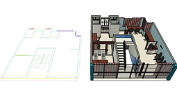
BIM-GIS Integration for Infrastructure & Smart Cities
This solution integrates Building Information Modeling (BIM) with Geographic Information Systems (GIS) to create a unified platform for smart city planning, infrastructure management, and real-time monitoring. The synergy between 3D design data and geospatial intelligence enhances decision-making, operational efficiency, and sustainability across urban projects.
Smarter Urban Planning with Integrated 3D GIS Context
-
Combining 3D BIM models with GIS layers enables planners to visualize cityscapes in real-world context. This supports better zoning, land-use decisions, and infrastructure forecasting.
.jpeg)


Streamlined Facility Management through Spatial Asset Mapping
-
BIM-GIS integration allows real-time access to building components and utilities on an interactive map. This makes maintenance, inspections, and repairs faster and more accurate.


Real-Time Monitoring of Infrastructure and Utilities
-
Sensors embedded in infrastructure can feed live data into GIS dashboards linked with BIM elements. This enables instant alerts and predictive maintenance for critical assets.
3D Data Model for HSR Layout of Bangalore

Digital Twin Implementation for Smart Urban & Industrial Management
This solution brings together GIS, BIM, IoT, and AI to create dynamic Digital Twins—virtual replicas of urban and industrial systems. These digital models enable continuous monitoring, predictive analytics, and informed decision-making, making cities and industrial zones smarter, more resilient, and highly efficient.
Multi-Layer Geospatial Data Integration
-
Combines high-resolution road network shapefiles with administrative point datasets (like HQs or local facilities) to build a detailed spatial model for analysis.


Real-Time Monitoring & Predictive Analysis
-
By integrating IoT, AI, and GIS-based analytics, the system enables continuous tracking of urban infrastructure, reducing risks and enhancing sustainability.
Graph-Based Path Optimization
-
Applies Dijkstra’s algorithm and hierarchical clustering to identify optimal routes, minimize travel distances, and analyze network redundancy for improved planning.
Carbon Net Neutrality
This solution offers a comprehensive roadmap to achieve carbon neutrality by integrating emission reduction, carbon sequestration, offset mechanisms, and policy engagement. Aligned with the Paris Agreement and ESG goals, it empowers organizations and governments to transition toward sustainable, low-carbon futures.
Emission Reduction Strategies
-
Implements clean energy transitions, energy efficiency upgrades, and sustainable transportation initiatives to drastically reduce greenhouse gas (GHG) emissions at the source.
Carbon Sequestration Initiatives
-
Promotes nature-based solutions like afforestation, reforestation, and soil carbon enhancement to naturally absorb carbon from the atmosphere.
Carbon Offsetting Mechanisms
-
Invests in certified carbon credit projects and emerging technology-based solutions to balance unavoidable emissions and drive global offset markets.


Methane Emission Detection and Management
This solution delivers a fully integrated system for detecting, quantifying, and managing methane emissions across sectors such as oil & gas, agriculture, and waste. Using satellite technology, IoT sensors, GIS, and AI, it enables real-time leak detection, efficient mitigation, and regulatory compliance — critical steps in reducing one of the most potent greenhouse gases.
Advanced Detection Technologies
-
Combines satellite imagery, ground-based sensor networks, and machine learning models to identify methane hotspots with high precision and temporal frequency.
Geospatial Data Integration & AI Analysis
-
Utilizes GIS platforms and intelligent algorithms to map emission sources, analyze spatial patterns, and forecast risk zones for targeted action and optimized resource allocation.
Mitigation & Repair Strategies
-
Implements rapid leak repair protocols and emission-reducing technologies to minimize environmental impact. Enables predictive maintenance to prevent future leak events.


Urban Heat Island Mitigation
This solution addresses the Urban Heat Island (UHI) effect, where built-up areas experience significantly higher temperatures than their rural surroundings. Through the strategic integration of nature-based solutions and climate-resilient urban design, the project reduces ambient temperatures, cuts energy demand, and fosters healthier, more livable cities.
Reduced Ambient Temperatures In Urban Areas
-
By increasing urban greenery, incorporating cool roofs, and enhancing shading structures, the project will significantly lower local temperatures. This reduction in the Urban Heat Island (UHI) effect will create a more livable and climate-resilient urban environment.
Lower Energy Consumption Due to Decreased Cooling Needs
-
A cooler urban environment reduces the demand for air conditioning, cutting energy consumption and lowering electricity costs. This directly benefits businesses, households, and city infrastructure, leading to long-term economic savings and improved energy efficiency.
Improved Air Quality and Public Health
-
Reducing urban temperatures helps lower ground-level ozone formation, decreases air pollution, and minimizes heat-related illnesses. This project supports healthier urban living conditions, reducing respiratory diseases and improving overall community well-being.


Environmental Sensing Networks
This solution establishes a robust Wireless Sensor Network (WSN) to continuously monitor key environmental parameters in real time. By integrating sensor technologies with geospatial platforms and predictive analytics, it empowers proactive environmental management, hazard response, and policy development.
Advanced Detection Technologies
-
Combines satellite imagery, ground-based sensor networks, and machine learning models to identify methane hotspots with high precision and temporal frequency.
Geospatial Data Integration & AI Analysis
-
Utilizes GIS platforms and intelligent algorithms to map emission sources, analyze spatial patterns, and forecast risk zones for targeted action and optimized resource allocation.


Mitigation & Repair Strategies
-
Implements rapid leak repair protocols and emission-reducing technologies to minimize environmental impact. Enables predictive maintenance to prevent future leak events.
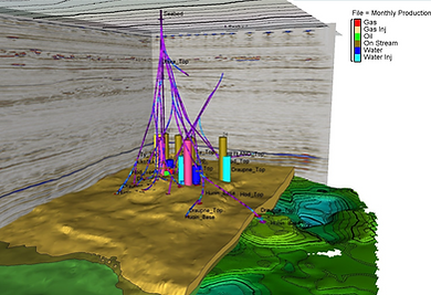
Predictive Analytics for Water Management
This solution integrates predictive analytics with water management systems to forecast demand, detect risks, and support proactive infrastructure planning. By leveraging historical and real-time data, it enables smarter decision-making for utilities, municipalities, and industries managing critical water resources.
Comprehensive Data Collection
-
Gathers and integrates historical water usage records with real-time sensor inputs, offering a complete view of consumption trends and system performance.
Intelligent Demand Forecasting & Risk Assessment
-
Applies machine learning to predict future demand and detect anomalies, helping avoid shortages, reduce waste, and anticipate infrastructure stress points.
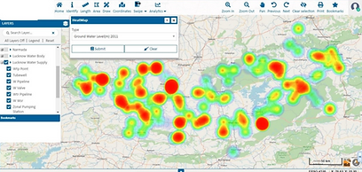

Flash Flood Management and Mitigation
This solution establishes a robust Wireless Sensor Network (WSN) to continuously monitor key environmental parameters in real time. By integrating sensor technologies with geospatial platforms and predictive analytics, it empowers proactive environmental management, hazard response, and policy development.
Model 1: Live Monitoring-Based Approach
-
Utilizes IoT sensors and real-time feeds to monitor rainfall intensity, water levels, and drainage conditions. Includes live dashboards and automated reporting for timely flood alerts.


Model 2: Spot-Based Containment Analysis
-
Focuses on vulnerable zones by simulating localized inundation, containment scenarios, and rain-triggered flood dynamics for rapid intervention planning.