top of page
20250919_1444_Maharashtra's GIS-Driven Future_simple_compose_01k5gkxf49fbhasb2gdb1bq6xh.pn

Live Online GIS Training in Maharashtra — Professional GIS Certification for Students Across Pune, Nagpur, Nashik & Mumbai

Industry-standard GIS training with real-life projects in urban planning, agriculture, disaster management, and environmental monitoring — designed for Maharashtra’s diverse needs.

Why GIS in Maharashtra ?

Maharashtra’s diverse geography and rapid urban growth make GIS indispensable. From Mumbai’s coastal vulnerability to flooding and Pune’s smart city initiatives, to agriculture in Vidarbha and forest monitoring in Western Ghats, GIS supports disaster management, sustainable planning, and resource management. Cities like Nagpur, Nashik, and Aurangabad are adopting GIS for infrastructure, mining, and urban expansion, while coastal regions rely on GIS for climate resilience and marine ecosystem monitoring.

For students in Maharashtra, learning GIS today means building skills for climate resilience, urban development, agriculture optimization, and environmental conservation, while unlocking high-demand career opportunities across India’s largest industrial state.

Why Now ?

India Page (21).jpg

Smart City Expansion in Pune & Nagpur — GIS is powering transport planning, infrastructure mapping, and smart governance.

India Page (22).jpg

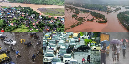
Disaster Management in Mumbai & Konkan — GIS aids in flood prediction, cyclone preparedness, and coastal resilience.

India Page (23).jpg

Agriculture in Vidarbha & Marathwada — Precision farming, crop yield prediction, and soil mapping rely on GIS & remote sensing.

India Page (24).jpg

Mining & Industrial GIS in Nashik & Chandrapur — Resource mapping and environmental compliance drive demand for GIS skills.

India Page (25).jpg

Forests & Biodiversity in Western Ghats — GIS supports forest monitoring, wildlife tracking, and eco-conservation.

India Page (26).jpg

GIS Job Market Growth in Maharashtra — GIS analysts, remote sensing experts, and Web GIS developers are in high demand across Pune, Mumbai, and Nagpur.

Image by Amber Kipp

Urban/Regional Planner

Screenshot 2025-08-19 183601.png

Remote Sensing Analyst

6501ecea2aff7d3c50e0a0d2_iStock-123252122.jpeg

Forest & Land Use Surveyor

Screenshot 2025-08-19 183834.png

Mining GIS Technician

Screenshot 2025-08-19 183956.png

Field Data Collection Specialist

Interactive Map

 [ This interactive map displays GIS-related organizations in Maharashtra, using blue pins for government and research groups and orange pins for the private sector. You can click on any pin to view details or use the checkboxes to filter organizations by category.. ]

Career Opportunities in Maharashtra with GIS Skills

As India’s largest industrial state, Maharashtra offers GIS careers in urban planning, disaster management, agriculture, mining, and IT-enabled geospatial services. With Mumbai, Pune, and Nagpur as major hubs, opportunities are growing across both public sector organizations and private companies.

Government & Research

Maharashtra Remote Sensing Application Centre (MRSAC), Nagpur.jpeg
BMC (Brihanmumbai Municipal Corporation), Mumbai.png
Forest Department.jpg
Geological Survey of India (Mumbai Office).jpeg
Pune Smart City Development Corporation.png

Private & IT Sector

channels4_profile
Screenshot 2025-08-19 182017_edited
Screenshot 2025-09-19 120135_edited.jpg
reliancejio_edited
Tech Mahindra.png
download (3)

Our GIS Training Programs

Advance your career with online GIS courses in Kerala, tailored for students and professionals across Trivandrum, Thiruvananthapuram, Wayanad, Kochi, Kollam and other key regions. Learn industry-standard tools like QGIS, ArcGIS Pro, PostGIS, and Google Earth Engine, plus programming & tool automation using Python libraries such as GeoPandas, Shapely, Rasterio, Folium, PyQGIS/ArcPy for end-to-end geospatial workflows. while working on projects relevant to Kerala’s unique geography — from flood resilience in coastal cities to forest monitoring in Wayanad. Earn a GIS certification that boosts your employability in both government agencies and private sector roles.

GIS Desktop Level 1

QGIS, ArcGIS Pro, Raster Analysis & Web Mapping

Kickstart your GIS journey with essential desktop tools. Learn mapping, digitization, raster analysis, and web publishing using QGIS, ArcGIS Pro, and real datasets tailored to Pune and beyond.

Duration- 2 Months

GIS Development Level 1 (Standard)

Python, GEE, PostGIS & Dashboard Automation

Designed for users with desktop GIS experience. Dive into coding and automation with Python, Google Earth Engine, PostGIS, and dashboard building for real-world GIS workflows.

Duration- 3.5 to 4 Months

GIS Development Level 1 (Advanced)

Automation, Remote Sensing & 3D GIS Workflows

Advance into industry-standard geospatial development. Learn automation with Python, remote sensing in GEE, and 3D GIS workflows including BIM integration and web dashboarding.

Duration- 7 to 7.5 Months

GIS Development Level 2

Full Stack GIS, APIs, AI Models & Cloud Deployment

Become a Full Stack Geospatial Developer. Build APIs, deploy web GIS apps, integrate ML models, and manage real-time spatial data streams with cloud infrastructure.

Duration- 7 to 8 Months

live-stream-or-online-session-icon-vecto

Live Online Training

Untitled design (1).jpg

Industry Standard Content

Untitled design (2).jpg

Real-World Projects

Untitled design (20).png

Research Paper Publication

Untitled design (19).png

Get Placed In Top GIS Organizations

Reviews & Testimonials

I am extremely grateful to AGSRT for providing me with the opportunity to successfully complete the ArcGIS Pro and ArcPy Developer Course in the Trivandrum branch . The training was well-structured, hands-on, and gave me a solid foundation in GIS analysis and automation using Python.

As part of the program, I also completed a 2-month internship at Agsrt Bangalore, where I worked on real-world GIS tasks, including spatial data digitization, raster data analysis, and Python-based geoprocessing automation, which gave me a clearcut idea about project handling .In the initial time I was just tensed about doing a project work but the management team at the office was very friendly and when i asked doubts , they gave me clarified answers and thereby gave me a strong support in my weak areas to perform well.This experience greatly enhanced my technical skills and gave me confidence to handle GIS projects independently.
I sincerely thank AGSRT for this valuable learning experience and highly recommend their courses to anyone aiming to build a strong career in GIS and remote sensing.

Amal Ar

Our Recruiters

wipro-company2-removebg-preview-removebg-preview
deduce_technologies_logo-removebg-preview-removebg-preview
images-removebg-preview
download-removebg-preview (1)
1631300595166-removebg-preview-removebg-preview
1491975769-Survey-of-India-removebg-preview
EAGLEVIEW-LOGO-COLOR
aidash-logo
43-ULTS
Dsmgeodata
unnamed
images-removebg-preview (1)
download-removebg-preview-removebg-preview

Demo Sessions

Symbology

Model Builder

Raster- Composite  (Image)

Georeferencing

Layout

Geodatabase

Awards and Recognitions

We are
ISO 9001 : 2015

Quality Management Systems

Certified Company

logo
meridian-uaf-logo_edited

Phone

+91 80-35647405

+91 9742349602

Email

Connect

  • Instagram
  • Facebook
  • LinkedIn
  • YouTube
bottom of page